Monday, February 28, 2011
Sunday, February 20, 2011
President's Day
 Would you trust any one of these three with your country? .... That's what I thought.
Winter ended as abruptly as it began. Thursday the 10th saw lows of 9 here at Mike's Weather World with -18 reported in Fayetteville and -21 at XNA airport where they had nearly 2 feet of snow. Then the pattern changed and within a week some places in NE Oklahoma had a 100-degree turnaround. Like the signs on I-70 approaching Denver say: "Don't be fooled". Winter is not over. In fact look for a move to more seasonable weather this week. Temps will fall some on President's Day and we will probably hit the freezing mark Tuesday morning.
On another note....how bout them quakes. Greenbrier, north of Conway, has experienced dozens of earthquakes in the past week or so. Several have registered at 3.0+ and one even hit 4.1. Some say it's a result of the natural gas drilling in the region, but I disagree. There was a swarm of small quakes near that area back in 1982 near the town of Enola. And if you are an earthquake junkie you can go the USGS site and register to receive emails and or text alerts when quakes hit a certain area. Filters allow you to choose the magnitude and area the alerts. Mine is set to text me for any quake in Arkansas with a magnitude of 3.0 or higher. Most of these quakes are less than 3.0.
Wednesday, February 9, 2011
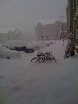
Snowmageddon
Mike's Weather World has just 6 inches of snow with maybe another inch or tow to fall. Northwest Arkansas has taken the brunt of this storm. The header pic if out my back door. The pictures below are from John who lives on the west side of Fayetteville. He got about 18 inches of snow. Some towns in Washington and Benton counties topped the two foot mark. We may get a new record for snowfall from one storm which was 25 inches in Corning a long time ago. I'll kwwp you updated.


Sunday, February 6, 2011
One more week of Winter

 I got a picture of this guy on our neighbor's roof. Evidence shows he's been here before. Most of the time this Blue Heron walks around in the lake behind our house in search of food.
 Let's talk weather for a moment. Friday's 2 inch show is melting away this afternoon...but more could come overnight. The big event is still set for Tuesday night and Wednesday. We will wait and see.
Indications are the Arctic Oscillation Index if moving back into an area that should mean more normal weather by next week.
Thursday, February 3, 2011
Groundhog apparently on Drugs
 Phil may have called for an early springs, but you couldn't tell it from what's happening around the country right now. This is an unbelievable Arctic outbreak. Snow and ice in northern Mexico with temps in the single digits. El Paso TX with lows near zero. Warmer this morning in Fairbanks AK than Oklahoma City. Lucky the Super Bowl will be inside Jerry World. Also this is the only time I can remember a Winter Storm Warning stretching along the entire gulf coast of Texas. Freezing rain on South Padre Island and schools canceled in far south Texas. Houston may see a couple of inches of sleet and snow.
 Mike's weather world has been below freezing for several days now with a high today of only 24. There is a chance of snow late tonight and tomorrow. Maybe a light accumulation here, but Kelly may see a couple of inches. She will let us know. We may see a little more Sunday,and a bigger storm may come in the middle of next week. One thing is for certain - there will be another blast of arctic air next week.
Now here's the good news. If this is global warming, then I love it and we need to globally warm some more. Here is an interesting link from Joe Bastardi at Accuweather about more cold winters to come. This is a must read.
Now, to finish for today here is an interesting phenomena caused by extended cold weather. It's been below freezing so long that moisture in the ground has frozen and pushed up out of the ground. Very inpressive....


Keep Mike's Weather World up to date on your winter weather.
Subscribe to:
Comments (Atom)